Contents
Index
Entering Easements
Easements are input as separate parcels and joined to the host parcel, either manually or as part of a grouped fabric. Details of easements may also be input after the parcel close with appropriate line codes applied. This will not affect the validity of the dataset and will not result in errors in the adjustment but it is strictly more correct to enter easements as separate parcels to be joined to the fabric in the usual way. This reflects the relevance of the easement to a particular title.
The tools for adding easement information are accessed by right clicking from within the "Lines" grid in Parcel Properties.
GeoCadastre has a number of tools to facilitate entering easements. To use them effectively it is important to include connections to easement points when doing the data entry of the parcel that the easement will be joined to. This is often centrelines that are added during data entry for the parcel close.
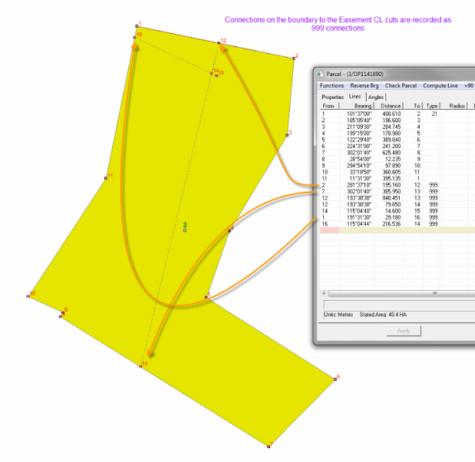
Some easements are shown on plans with full dimensions with connections to the easement points on the parcel boundaries. These connections should be entered after the parcel close by entering the connection lines and adding a "Type" 999 to each of these connections.
The points of the connections that have been added to the parcel are then used to construct the easement as a separate parcel, which is described in the next step.
Once the Centre Line for the easement is entered from connections on the boundary of the parcel, the geometry for the easement can be constructed as follows:
1. In the Parcel Tree, right click on the parcel that the easement is to be joined to and select "New Parcel in Group". See Grouping Parcels
2. Enter the details for the easement in the "Parcel Properties" and then select the "Lines" tab.
3. Enter the centreline of the easement by clicking on the relevant points in the graphic.
This is done by first making sure that you click in the "From" column in the first line of the "Lines" grid to make this cell active.
Then select the first point in the graphic so that this point number appears as the first point in the easement.
You must then click in the "To" column in the same line of the grid to make this cell active.
The second point can now be selected in the graphic so that it appears as the end point for the first line of the easement.
You will notice that as you select the second point, the bearing and distance for this line will appear in the grid as the first line in the easement parcel.
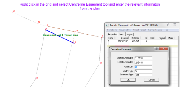
4. Right click anywhere in the "Lines" grid and select Centreline Easement.
5. Enter the relevant information in the window which appears.
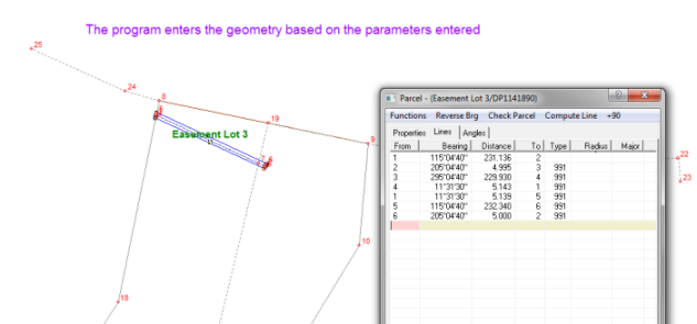
6. Hit OK and the program automatically adds the geometry for the easement parcel.
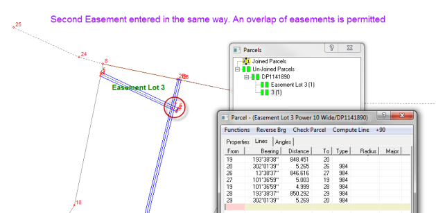
This plan has a second easement which is also a power easement. The second easement is entered in the same way as the first, as a "New Parcel in Group".
Overlaps are permitted to cover the situation where easements for different purposes can be granted over the same area.
The Easements that have been entered will appear as un-joined parcels in the Parcel Explorer tree until that group of parcels has been joined.